
What Is an ALTA Survey and When Do You Need One?
Most property owners will never need an ALTA survey. But if you are buying commercial property, refinancing a large loan, or dealing with land that has a complicated history, someone in the process will likely ask for one. Knowing what it is ahead of time makes the whole process a lot less confusing.
What Is an ALTA Survey?
An ALTA survey is a land survey that follows a set national standard. That standard is created and updated by two organizations: the American Land Title Association and the National Society of Professional Surveyors. The rules were last updated in 2021.
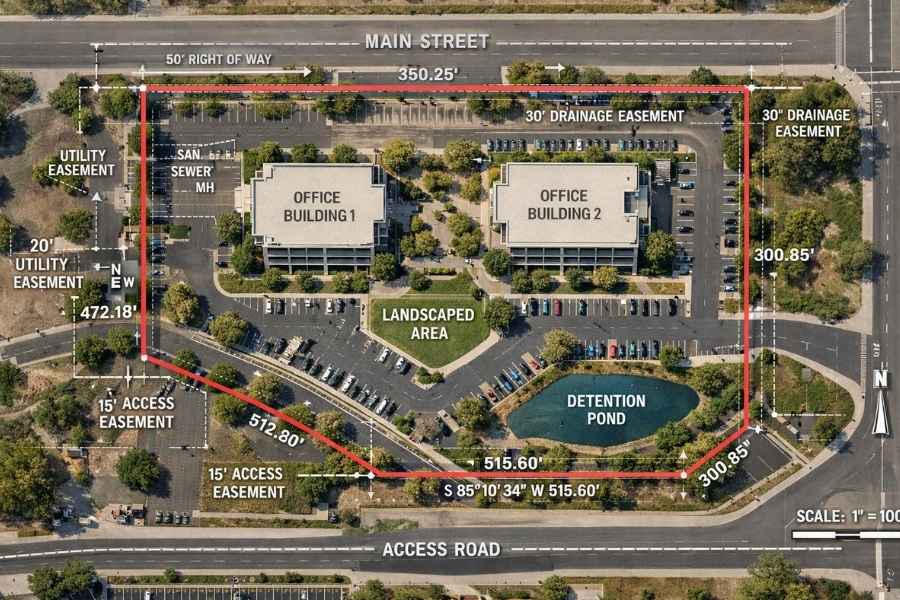
What sets it apart from other surveys is how much detail it captures. It does not just show where your property lines are. It also documents easements, encroachments, utilities, buildings, zoning information, and flood zone data, all on one certified document.
Because every ALTA survey follows the same national rules, a lender in New York and a title company in Alabama can both read the same document and understand exactly what it shows. That consistency is why it is trusted in big, high-stakes transactions.
Who Creates the ALTA Survey Standards?
The standards come from the American Land Title Association and the National Society of Professional Surveyors. These two groups work together to define what must appear on every ALTA survey and how it must be signed off. The rules are reviewed every five years.
Only a licensed land surveyor can certify an ALTA survey. That surveyor must also be licensed in the state where the property is located.
What Does an ALTA Survey Include?
A standard ALTA survey covers all of the following:
- Property boundary lines and legal description
- Easements and rights-of-way that affect the land
- Encroachments from nearby properties or structures
- Location of buildings, parking lots, fences, and other improvements
- Visible utilities on or near the property
- Flood zone classification based on FEMA maps
- Zoning classification and setback requirements
- Access points and road frontage
The 19 Optional Table A Items
ALTA surveys also include a list of 19 optional add-ons called Table A. Buyers, lenders, or title companies can pick any of these items depending on what the deal requires.
Common examples include aerial photos, topographic data, parking space counts, square footage calculations, and underground utility locations. Each item added means more work for the surveyor and a higher overall cost.
What the Final Map Shows
The finished ALTA survey is a detailed map of everything found during the survey. It shows all boundary line measurements and directions. It notes any gaps or overlaps with neighboring properties. It identifies all easements using recorded information. Every feature that could affect how the property is owned, used, or financed appears clearly on the map.
When Do You Need an ALTA Land Survey?
Commercial Real Estate Transactions
This is the most common reason. When someone buys commercial property, the title company handling the sale almost always requires an ALTA survey before issuing title insurance. Title insurance companies use the survey to check for problems before agreeing to insure the property. Without it, they cannot be sure what they are covering.
Refinancing or Securing a Large Loan
Lenders who finance commercial properties often require an ALTA survey as part of approving the loan. The survey confirms that the property being used as collateral is accurately described and free of hidden problems.
Properties With Complicated Histories
Some properties have a history of boundary disputes, multiple easements, or unclear deed records. In those cases, even a residential buyer or attorney might request an ALTA survey to get a full picture of what the property includes and what restrictions come with it.
How Much Does an ALTA Survey Cost?
ALTA surveys cost more than regular property surveys because they involve much more work. For a typical commercial lot, the price usually falls between $2,000 and $3,000. Larger properties, sites with many Table A items added, or land with a messy boundary history can push the cost above $10,000.
The price covers the time needed to research deed records, find and document all easements and encroachments, complete detailed field work, and produce a certified map that meets national standards. It is a bigger job than a standard boundary survey, and the cost reflects that.
ALTA Survey vs. Boundary Survey: Key Differences
These two surveys are used in very different situations.
| Feature | ALTA Survey | Boundary Survey |
| Primary use | Commercial transactions | Residential properties |
| Follows national standard | Yes | No |
| Documents easements | Yes, in detail | Sometimes |
| Includes Table A options | Yes | No |
| Accepted by title insurers | Yes | Not always |
| Typical cost | $2,000 to $3,000+ | $300 to $1,500 |
A boundary survey works well for most residential property needs. An ALTA survey is built for situations where more is at stake and the paperwork needs to meet a recognized national standard.